Oh no, I broke ArcGIS Online!
If you logged into ArcGIS Online in the past few days, you may have been greeted by a nasty note about exceeding […]

If you logged into ArcGIS Online in the past few days, you may have been greeted by a nasty note about exceeding […]
Ever wanted to get a glimpse of what your town or school looked like some years ago? If you search for something […]
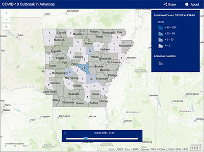
You’ve probably seen maps and dashboards, like the one from the Arkansas Department of Health, showing current information about the COVID-19 outbreak […]
ArcGIS Online managers can bulk export their Organizations Named Users into a comma separated file (.csv) using the new Reporting Tool ( […]

You can use our Public Survey123 application to contribute Public or Free WiFi access locations within Arkansas. These Free Wifi locations are […]
We recently discovered this great Animal Tracking tutorial from Potter County, Pennsylvania and thought it may inspire others to leverage ArcGIS Storymaps […]
The ArcGIS Online US Geological Survey (USGS) topographic map collection now contains over 177,000 historical quadrangle maps dating from 1882 to 2006. The USGS Historical […]
The 2020 EAST conference was unfortunately cancelled due to Covid-19 this year but many presentations and competitions were held online/virtual. We’re happy […]
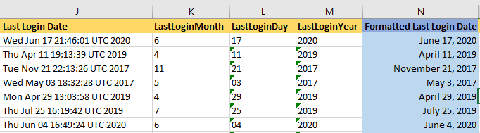
Arcade is a new expression language that ESRI has created for use within the ArcGIS platform. It’s a portable, lightweight, and secure […]
Welcome to the EAST GeoTalk blog! This serves as a forum for the EAST Geospatial Support Team to share news, tips, and […]